Executive Doctor of Geospatial Leadership

Students review data with Geography Professor Dominik Kulakowski.
Develop leadership in four key areas
- Strategic leadership in the geospatial sector: understand emerging technologies, markets, regulatory environments, and industry structures shaping the future of geospatial enterprises.
- Fluency in geospatial technologies: develop executive-level literacy across GIS, Earth observation, cloud-native systems, AI-driven geospatial analytics, digital twins, and data platforms.
- Executive management and business acumen: build advanced skills in strategy, finance, organizational leadership, governance, marketing, and executive communication, tailored specifically to geospatial organizations.
- Applied leadership capstone project: lead a high-impact, real-world project addressing a critical challenge or opportunity within an organization or industry sector, with input from industry executives.
Clark’s industry advantage
Deep expertise in applied research, sustainability, climate risk, spatial analytics, finance, and business
Global leadership in geographic information science, Earth observation, and GeoAI
Close partnerships with industry leaders through the Clark Center for Geospatial Analytics, allowing students to learn from and network with employers
Ongoing collaboration with the World Geospatial Industry Council and industry leaders — Esri, Oracle, Amazon Web Services, TomTom, Hexagon, and more
Industry-connected by design
Developed in direct consultation with geospatial industry leaders, the DGEO features:
- Executive guest speakers and practitioners
- Industry-sponsored student participants
- Applied case studies and real-world challenges
- Capstone projects designed to produce measurable organizational value
Admission requirements
- A bachelor’s degree from an accredited institution
- 7+ years of professional experience in geospatial or related fields
- A statement of purpose outlining leadership goals
- Two professional letters of recommendation
- A current résumé
- Interview with program faculty
English language requirements follow Clark University graduate admissions standards.
Frequently asked questions
Why is Clark launching this program now?
The geospatial industry has reached an inflection point. Like AI, it has become one of the leading technologies shaping the future of society, enabling everything from navigation to climate monitoring to land use analysis.
As the geospatial technologies industry matures, its founding generation of leaders is stepping back, creating a significant leadership gap with no established pipeline to fill it.
The Executive Doctor of Geospatial Leadership is designed to close that gap. It is the first professional doctorate in the sector, building a credentialed leadership pipeline for an industry at a pivotal moment.
How is Clark addressing the needs of the global geospatial industry?
Clark’s Executive Doctor of Geospatial Leadership was developed in partnership with the World Geospatial Industry Council, in direct consultation with geospatial industry leaders. The WGIC represents more than 50 member organizations, including major players like Esri, Oracle, Amazon Web Services, TomTom, and Hexagon.
Geospatial technology cuts across the global economy, and the geospatial sector is rapidly expanding. At a time when the world faces the ongoing impacts of climate change, the industry has become even more central to the future of society,
Clark’s DGEO program will equip working professionals with the geospatial technical and executive skills needed to lead organizations at this critical moment.
Why was Clark chosen to house the world’s first DGEO program?
The Executive Doctor of Geospatial Leadership draws upon Clark’s foundational strengths in geographic information science, embodied in the Graduate School of Geography and the Center for Geospatial Analytics, both of which are housed in the School of Climate, Environment, and Society.
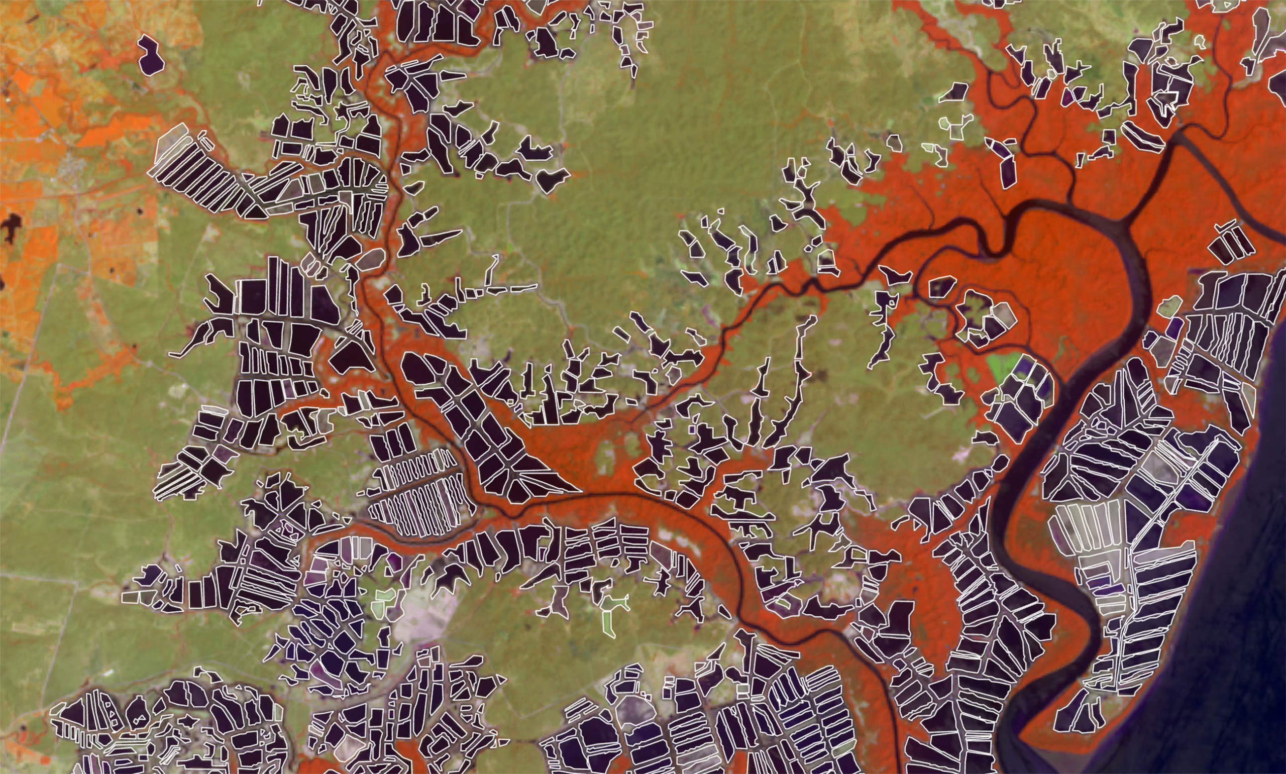
Clark faculty and students conduct research at the forefront of artificial intelligence, land cover and land use change, biodiversity conservation, urban sustainability, and natural hazard risk.
With a rapidly changing environment, the DGEO program strengthens both knowledge and resources in areas that matter most. True to Clark’s mission of preparing emerging leaders to address society’s greatest challenges, the Executive Doctor of Geospatial Leadership combines experiential learning, meaningful partnerships, and bold applied problem-solving to develop the next generation of geospatial leaders.
At Clark, the DGEO will particularly concentrate on the emerging areas of technological innovation where Clark is a world leader: AI-driven geospatial analytics, cloud-native geospatial, Earth observation data streams and sensors, and 3D/4D digital twins.
Clark also has an AACSB-accredited School of Business, a critical partner in providing students with the knowledge and skills they need for executive leadership, finance, and enterprise strategy.
Why does the industry need Clark to offer a specialized geospatial- and climate-focused professional degree?
Historically, geospatial executives rose through the ranks as the industry matured — many professionals with deep technical backgrounds and business acumen developed their skills and experience on the job.
With the retirement of this founding generation and the ongoing expansion of the sector, there is a clear gap: Mid-career professionals need targeted training to step into senior leadership roles. The rise of AI as a critical capacity within geospatial technologies — called GeoAI — makes that need even more urgent. The Executive Doctor of Geospatial Leadership is designed to address this leadership gap.
Who are the partners affiliated with the DGEO program?
Developing the next generation of geospatial leaders requires the combined force of academia, industry, and peer institutions working in concert.
Clark’s Executive Doctor of Geospatial Leadership program has several core partners:
- Clark University’s School of Climate, Environment, and Society and the Clark Center for Geospatial Analytics: With a decades-long history as a leader in geospatial sciences — including our longtime collaboration with leading industry and government organizations such as Esri, NASA, and NOAA — Clark is the perfect home for the new DGEO degree to equip the next generation of geospatial leaders.
- Clark University’s School of Business, which has been ranked among the U.S. News & World Report Best Business Schools — full-time MBA— Fortune Inc. Top MBAs, and included in Princeton Review’s Best Business Schools.
- The World Geospatial Industry Council, which represents more than 50 member organizations across the global geospatial sector, including Esri, Oracle, and Deloitte. The council is a co-creator of the program, ensuring the curriculum is directly responsive to the leadership needs of the industry it serves, and remains an active partner in connecting students to the broader professional ecosystem.
In addition, the University of Southern California is independently developing a parallel program, launching simultaneously with Clark’s. While the two institutions are building distinct degrees, they are in ongoing consultation to foster basic consistency as both programs enter the market together, signaling a coordinated, sector-wide response to the geospatial leadership gap.
How are industry employers involved in the program?
Industry is embedded in the Executive Doctor of Geospatial Leadership by design. Employers engage through executive guest lectures, sponsored student participants, applied case studies, and hands-on innovation labs during residency weeks. The Capstone Project is coached by both faculty and external industry partners, ensuring it produces real organizational value.
The Clark Center for Geospatial Analytics serves as the formal liaison with industry partners, working to bring real-world use cases into the classroom and expand the program’s network over time. Through World Geospatial Industry Council membership and an active alumni community, students gain access to executive mentorship and lasting professional connections across the sector.
Who is the ideal candidate for this program?
The Executive Doctor of Geospatial Leadership is designed for mid- to senior-career professionals with seven or more years of experience in geospatial observation, GIS, remote sensing, or GeoAI. The program’s low-residency, cohort-based format allows students to maintain their current roles while preparing to lead geospatial enterprises, innovation teams, and data-driven organizations at the highest level.
Which fields and sectors need graduates of the DGEO program?
Geospatial technology has matured into a horizontal capability cutting across the entire global economy. It is the “engine” underlying many of the critical decisions we face today — calculating the fastest route for our morning commutes, monitoring where our food is sourced, predicting which neighborhoods might flood, tracking global shipping routes, or mapping the best sites for new energy projects.
Therefore, graduates will be positioned to step into senior leadership roles where geospatial information is rapidly becoming critical infrastructure, driving major business and environmental decisions.
Executive Doctor of Geospatial Leadership graduates will be prepared to lead across the full breadth of industries. They will lead in fields in:
- Insurance — predicting property risks from wildfires and floods, for example.
- Transportation and logistics — optimizing global shipping routes to cut down emissions.
- Urban planning — designing climate-resilient cities.
- Environmental monitoring — tracking deforestation and biodiversity loss in real time.
- And many more.
As geospatial information becomes ever more integral to these sectors, the demand for leaders who can bridge technical expertise and executive decision-making is growing dramatically.
How does this program differ from an MBA or a Ph.D. degree?
Although Clark’s Executive Doctor of Geospatial Leadership shares similarities with an MBA and draws upon the strengths of our School of Business, it operates at a doctoral level, combining business management with deep technical learning outcomes in an executive terminal degree.
Given the technical, managerial, and strategic demands placed on top executives in the geospatial sector, the DGEO is more focused and in-depth than a traditional MBA.
Clark’s Executive Doctor of Geospatial Leadership program was developed with the input of the World Geospatial Industry Council and geospatial industry leaders. Built with working professionals in mind, the DGEO’s key distinguishing features include:
- Primarily online coursework — synchronous and asynchronous — with two one-week, in-person residencies per year on Clark’s campus in Worcester, Massachusetts, and a three-day in-person orientation at launch.
- A cohort-based model that supports peer learning, collaboration, and professional network building.
- Problem-based learning built around real-world case studies and access to leading practitioners.
- Completion in two years (including summer study).
- An Applied Leadership Capstone Project addressing a critical challenge or opportunity within a real organization or industry sector.
What will DGEO participants learn?
Executive Doctor of Geospatial Leadership graduates will gain a deep knowledge of:
- Geospatial technology literacy: Common baseline of technical proficiency and fluency, enabling leaders from any specialization to effectively manage organizations across the entire sector.
- Geospatial sector strategic issues: Deeply explore current and future strategic questions, opportunities, and challenges for the evolving geospatial industry.
- Executive leadership capacities: Focus on building high-level management and leadership skills tailored for the sector.
What are the core courses in the program?
- Geospatial Everywhere: Exploring Ubiquitous Applications Across Industries
- Geospatial Strategy, Innovation, and Product Leadership
- AI for Geospatial Enterprises
- Leading a Learning Organization in the Geospatial Sector
- Strategic Finance and Value Creation in Geospatial Enterprises
- Geospatial Markets and Marketing Strategies
- Doctoral Capstone: Applied Geospatial Leadership Project