Working with Professor Pontius, Ph.D. student Antonio Fonseca aims to help scientists understand the ‘big picture’ in decades of land-cover data
Growing up, attending college, and working in Belém, Brazil, Antonio Victor Galvão da Fonseca observed firsthand how humans have changed the Amazon’s landscape — clearing forests, building roads, expanding cropland, extracting minerals, and disrupting rivers.
As a researcher at Imazon (Amazon Institute of People and the Environment), he produced maps and reports for policymakers on deforestation.
Now a third-year Ph.D. student in geography working with Professor Robert Gil Pontius Jr. in Clark’s School of Climate, Environment, and Society, Fonseca is using artificial intelligence and cloud computing to improve a free, open-source research tool available on GitHub. The tool allows users to process large datasets remotely and better analyze complex patterns of land change over time, in any region of the world.
“Without this tool, you would need a very powerful computer to analyze global land-cover data,” Fonseca says. “But with the tool, anyone can process the data because all the processing happens in the cloud. If you have a regular computer, a web browser, and a Google account, you can use it.”
The tool relies on land-cover maps derived from satellite imagery of the Earth, captured over four decades. The maps classify the landscape into categories, such as forests, grassland, cropland, and water.
Translating Pontius’ mathematical equations into Python code, Fonseca has expanded the tool to work with maps containing over a dozen land-cover categories. The tool allows users to detect land change in maps and datasets from multiple time periods. For instance, it could illuminate how cropland has encroached on forests or how a river has shrunk over several decades or just two years.
“In the past, we didn’t have enough data,” Fonseca says. “Now we have too much data, and the limitation is understanding it. We need tools that help people see what is most important.”
With Clark AI Innovation Fund grant, researchers further develop tool for worldwide use
Although the tool deals solely with historical data, it could allow conservation and GIS scientists, policymakers, and regional land-use planners across the world to uncover the patterns which, combined with further research, could help them understand the impacts of climate change over time and make future projections, he explains.
To support their research using AI to improve the land-cover data tool, Fonseca and Pontius were awarded a grant from the Clark AI Innovation Fund, established with a $50,000 gift from the Yee Family, including Trustee Brian Yee ’93.
Their project, they say, ultimately “will enable Clark professors to incorporate AI into GIS courses, elevating student computing skills previously limited by computing constraints.”
“As a Ph.D. student at Clark, it’s clearer to me that I want to produce something others can actually use — something that is open, reusable, and accessible.”
— Antonio fonseca
Fonseca’s AI work builds upon a novel methodology that Pontius developed with Thomas Bilintoh, Ph.D. ’24. Called “Trajectory Analysis,” it helps researchers identify frequently overlooked, yet meaningful, patterns in long-time series of land-cover maps. The team’s innovative methods are described in articles published last October and December in the open-access journal Transactions in GIS.
“The challenge is not producing more maps — it’s helping users understand what decades of change actually mean,” Fonseca says. “This tool can help scientists, map producers, and policymakers make better decisions based on the data.”
The researchers applied their methodology to a research project funded by a three-year, $750,000 NASA project led by Pontius and Geography Professor Gustavo Oliveira.
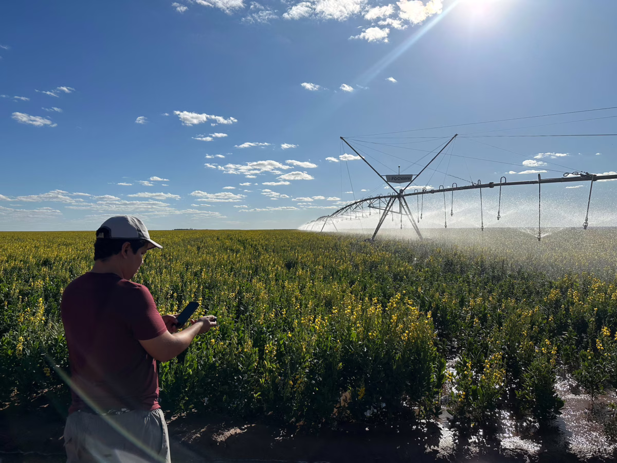
Since 2023, they have been investigating the impacts of large-scale agriculture and irrigation on water tables in the Cerrado savanna of Brazil’s western Bahia state. Deemed a significant carbon sink due to extensive plant root systems, the 789,000-square-mile Cerrado harbors the Earth’s second-largest underground water reservoir.
Fonseca and Steinbrecher Fellow Rowan Compton ’25, M.S. ’26, have been integral to the project, conducting summer field research in the region and conducting GIS analysis, according to Oliveira and Pontius.
“Our collaboration illustrates the excellent Clark educational approach of using professors’ funded research projects to build research teams that combine bachelors, masters, and doctoral students,” Pontius says.
Using FAIR Data Principles to make information accessible and reusable
Since coming to Clark, Fonseca says, his mindset around research outcomes has changed. In a course taught by Geography Professor Hamed Alemohammad, director of the Clark Center for Geospatial Analytics, he learned about the importance of sharing information and making digital data easily available to humans and machines, practices based on FAIR (Findable, Accessible, Interoperable, and Reusable) Data Principles.
“When I was a researcher in Brazil, most of the studies we published were related to something that affected policy,” he says. “Now, as a Ph.D. student at Clark, it’s clearer to me that I want to produce something others can actually use — something that is open, reusable, and accessible.”
To that end, Fonseca will get a chance to share what he has learned in trips to two upcoming conferences.
In April, he will travel to Athens, Georgia, to present research on “A Pixel-Level Framework for Map Comparison Through Time with Application to Water Mapping in Plum Island Estuary, MA [Massachusetts]” at the International Association of Landscape Ecology’s annual meeting. He received a NASA award to attend the conference.
In July, funded by the Clark AI grant, he will present on “Revealing Multi-Class Land Cover Dynamics through Cloud-Based Change Component Analysis” at the Ecological Society of America’s meeting in Salt Lake City.
Fonseca continues to draw a direct line from his current research interests to his childhood experiences in the Amazon, especially visiting his mother’s village, which has grown exponentially with an influx of city residents who have moved to the countryside.
“I saw a lot of deforestation and changes in the rivers as I grew up,” he says. “Now, as an adult, I see how different the region is. That experience is part of why I care so much about understanding these changes over time.”
Image at top of story: Antonio Fonseca has conducted research — including measuring and recording the land coordinates of irrigated soybean fields — over two summers in Brazil’s Cerrado as part of a NASA-funded research project led by geography professors Robert Gil Pontius Jr. and Gustavo Oliveira of Clark’s School of Climate, Environment, and Society. (Photo courtesy of Gustavo Oliveira)