TerrSet liberaGIS Geospatial Monitoring and Modeling Software
TerrSet is an integrated geospatial software system for monitoring and modeling the earth system for sustainable development. The TerrSet system incorporates the IDRISI GIS Analysis and IDRISI Image Processing tools along with a constellation of vertical applications. TerrSet freely offers the most extensive set of geospatial tools in the industry in a single package. There is no need to buy costly add-ons to extend your research capabilities.
Along with the software features mentioned below, TerrSet also includes utilities for import and export of all major file and imagery formats along with comprehensive documentation and tutorials.
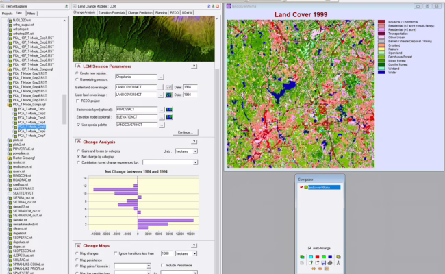
The Land Change Modeler (LCM) for analyzing land cover change, empirically modeling its relationship to explanatory variables and projecting future changes. From these, projections can be made of the expected land cover at a future date. The LCM dialogue in the image above shows the results of a Change Analysis for land cover in central Massachusetts. In this analysis we are able to see the loss/gain of each category in the legend.
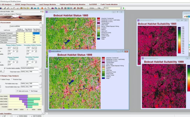
The Habitat and Biodiversity Modeler (HBM) includes a wide range of tools for habitat assessment and species distribution/biodiversity modeling. Locations are mapped into areas of primary and secondary habitat, primary and secondary corridor, and unsuitable lands based on land cover and habitat suitability. Parameters such as home range, size, buffer widths, and gap crossing distances are also used. In this example, land suitability for bobcats was assessed over fourteen years using land-use categories.
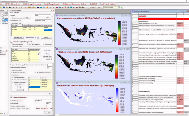
GeOSIRIS is a national-level planning tool for REDD (Reducing Emissions from Deforestation and forest Degradation). Developed in partnership with Conservation International, GeOSIRIS allows the user to specify the price of carbon, national level objectives for carbon emissions, the distribution of offset income between national and local levels, and a variety of economic parameters such as price elasticity of demand for agriculture on newly deforested land. GeOSIRIS empirically determines the effective opportunity cost based on a set of environmental variables and a provided map of potential agricultural revenue. Outputs include maps of expected carbon emissions with and without the proposed REDD policy as in the example for Indonesia above.